A day long circuit of the Lake District in the footsteps of Coleridge.

In a previous post I reflected on Samuel Taylor Coleridge’s account of his perilous descent from Scafell in 1802. The passage is widely-quoted as being the first recorded example of that now well-established genre of literature: non-fiction mountain adventure. Indeed, because the route he took (known as Broad Stand) is now graded a “Moderate” rock climb – and because climbs have to be recorded to be officially recognised – 1802 is often mentioned as being the Year Zero of the sport of climbing.
But the descent of Broad Stand was just one short incident in a much larger adventure. Coleridge was in the middle of a 9-day circular walking tour of the Lake District, starting from and finishing at his home in Keswick. Today, long walks are familiar to many, and a mainstay of the tourist industry in places like the Lakes. But in 1802, it was pretty much unheard-of to venture into the mountains for the sake of adventure alone. Coleridge was doing something highly unusual to head off on a hike like this, let alone almost fall down a mountain on the way.
Obviously, there is a fine line between adventure and foolhardiness, and Coleridge – without previous knowledge of Scafell, let alone map or compass – crossed it by descending Broad Stand. But his spirit of adventure in taking on the 9-day tour, in defiance of the conventions of the time, is still admirable. We all need a little bit of adventure now and then!
We know about Coleridge’s tour because his write-up of it, in the form of 2 letters and various notebook jottings, has survived. It’s available here and going through it, with a few OS maps alongside, it’s possible to plot the route he took all those years ago. An obvious thought follows – would it be possible to retrace this route, and perhaps get a better insight into what inspired his famous writings?
A little bit of research reveals it’s already been done. In 1989 local writer, the late Alan Hankinson, walked almost the entire route, and in 1991 his fine book Coleridge Walks the Fells was published. His walk was a very noble enterprise, in that it turns out that the vast majority of the route – mostly just tracks in 1802 – is now roads, and main roads at that. Hankinson reluctantly concluded that Coleridge’s spirit of adventure could not be recaptured by following his exact route on foot – and he said that nearly 30 years ago!
I had another day to me in the Lakes recently and decided to dedicate it somehow to Coleridge’s journey. In the end I settled on an acceptable compromise – a circular drive around the Lake District visiting various spots mentioned by Coleridge on his tour, plus a long journey on foot to where he went immediately after descending Broad Stand. Although this felt like trying to squeeze a 9-course meal into a lunchbox – and I’m not really in the business of recommending scenic drives! – it’s the best that could be done in 24 hours. A pretty full day as it turned out, but a rewarding one.
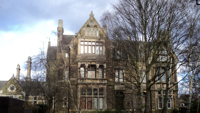
Coleridge started out from his home in Keswick – Greta Hall – just a couple of minutes walk from the town centre, but up on a hill and commanding a view that he raved about. It’s possible to walk up to the gates now and get a peep of this very fine residence and also the view of the mountains above today’s rooftops:
The route heads up the beautiful Newlands Valley, at the top of which is Moss Force, a disappointing spectacle on 1 August 1802 but a very fine one on 27 July 2017 after much heavy rain. Not often you can drive (and park!) so close to such a fine cataract:
 Dropping down to Buttermere, Coleridge’s route took him over Floutern Pass, but for the modern day driver you have to go round Crummock Water and Loweswater. I pressed on along the main road to Egremont, missing the diversion Coleridge took to St Bees. An unsucessful addition to his journey this turned out:
I walked on to St. Bees, 3 miles from Egremont-when I came there could not get a Bed-at last got an apology for one, at a miserable Pot-house; slept or rather dozed in my Clothes-Breakfasted there-and went to the School & Church ruins-had read in the history of Cumbd. that there was an ‘excellent Library presented to the School by James Lowther,’ which proved to be some 30 odd Volumes of commentaries on the Scripture utterly worthless- & which with all my passion for ragged old Folios I should certainly make serviceable . . . for fire-lighting.
I continued on the main road to Gosforth, trying not to think about Sellafield looming to the right, and then up Eskdale to the foot of Hardknott Pass where I switched to fellrunning gear. Across the fields was Taw House Farm, where Coleridge spent the night after his Scafell exploits and where he wrote the letter describing them:
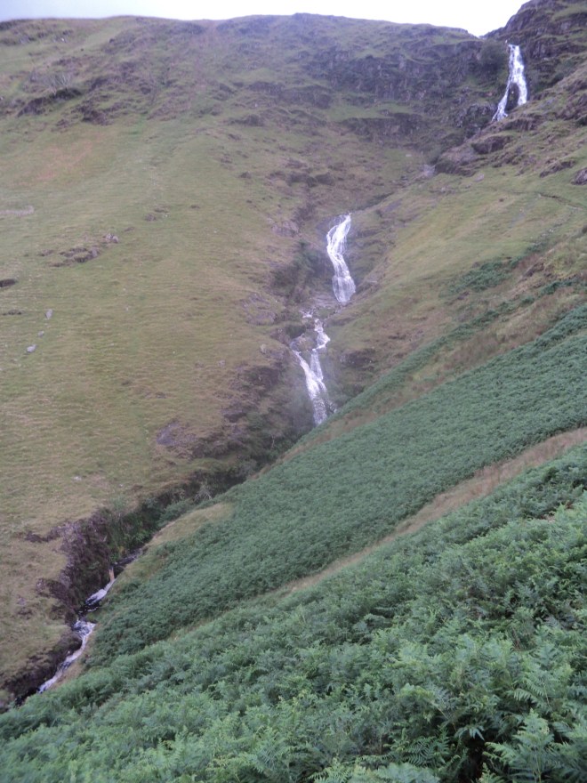
 I had a choice of routes here – either to keep to Coleridge’s route from Scafell to Taw House on the west side of the River Esk, or to stick close to the east bank of the river and join up with Coleridge’s route 3 miles higher up. Either way, I knew it was most likely I would have to return the same way, as the river was in spate and probably unfordable. I decided on the latter route, to view some of the dale’s impressive rapids and pools:
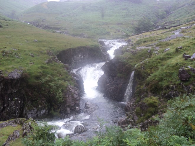 At the top, across the indeed-unfordable Esk, was the biggest fall of them all – Cam Spout – next to which Coleridge descended:
 Having done so…..
And now the Thunder-Storm was coming on, again & again!-Just at the bottom of the Hill I saw on before me in the Vale, lying just under the River on the side of a Hill, one, two, three, four Objects I could not distinguish whether Peat-hovels, or hovel-shaped Stones-I thought in my mind, that 3 of them would turn out to be stones-but that the fourth was certainly a Hovel. I went on toward them, crossing & recrossing the Becks & the River & found that they were all huge Stones…….
I came to a little village of Sheep-folds / there were 5 together / & the redding Stuff, & the Shears, & an old Pot, was in the Passage of the first of them. Here I found an imperfect Shelter from a Thunder-shower-accompanied with such Echoes! O God! what thoughts were mine! O how I wishes for Health & Strength that I might wander about for a Month together, in the stormiest month of the year, among these Places, so lonely & savage & full of sounds!
The stones are known as Sampson’s Stones, viewed here from the other side of the river with the sheepfolds to the left:
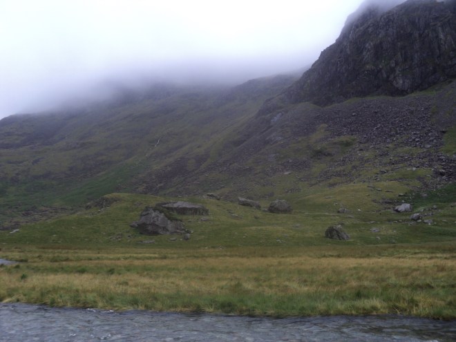 The low clouds were very suggestive of the weather Coleridge described. Indeed, the whole walk up the Esk was accompanied by the thundering sounds of falling water, which would have very much suited the author of “Kubla Khan” with its frequent references to water – sacred rivers, romantic chasms, mighty fountains and five miles meandering. Ceaseless turmoil seething indeed.
Returning to the car, I continued my own meanderings over Birker Fell and down to Ulpha Kirk in the Duddon Valley. Coleridge waxed lyrical about the place:
The Kirk standing on the low rough Hill up which the Road climbs, the fields level and high, beyond that; & then the different flights of mountains in the back ground, with wild ridges from the right & the left, running like Arms & confining the middle view to these level fields on high ground is eminently picturesque-A little step (50 or 60 yards) beyond the Bridge, you gain a compleatly different picture-the Houses & the Kirk forming more important parts, & the view bounded at once by a high wooded rock, shaped as an obtuse-triangle/or segments of a circle forming an angle at their point of junction, now compleat in a Mirror & equally delightful as a view/
Coleridge’s best friend in poetry, William Wordsworth, agreed about the area, so much so that a few years later he wrote a series of 34 sonnets dedicated to the River Duddon. Number 31 starts:
The Kirk of Ulpha to the pilgrim’s eye
Is welcome as a star, that doth present
Its shining forehead through the peaceful rent
Of a black cloud diffused o’er half the sky;
Happily, this particular pilgrim managed to take a photo just at the moment the sun shone on the shining forehead against a black cloud:
 The Kirk seemed rather distinctive with its bells on the outside and (in that very civilised fashion) the door was open so you could have look around inside.
The next part of the drive – from Ulpha over to Broughton Mills – was very pleasant along a quiet, gated road. I soon came to The Blacksmith’s Arms where Coleridge:
Dined on Oatcake & Cheese, with a pint of Ale, & 2 glasses of Rum & water sweetened with preserved Gooseberries
I thought about going in and asking for the same but had second thoughts, particularly when the staff came out the front for a fag break. A lovely looking inn though:
 My head used to feel a bit like that anvil after spending too much time in places like this back in the day….
Once you’re over the next hill into Torver the return to Keswick is a long way by main road, roads familiar to generations of visitors to the Lakes. I did stop off quickly at one famous spot well known to Coleridge – Dove Cottage in Grasmere, his mate Wordsworth’s place. But when Coleridge passed on this occasion he didn’t stop for long – William and his sister Dorothy were away, en route to France to visit Annette Vallon, with whom Wordsworth had had a child – Caroline – several years before, a fact known to Coleridge but not to the general public until the 1920s! This was August 9 1802 – 4 weeks later, and still on the road to France, Wordswoth wrote one of his most famous poems – “Composed upon Westminster Bridge, September 3, 1802”.
 Well, that was a long day in the Lakes, but a memorable one. Obviously, you can only take so much in from behind the wheel, but I felt I got some sense of Coleridge’s tour from my journey, helped of course by the excursion into the wilds of Eskdale. Coleridge would have felt his circuit was taking him off into the unknown; to do that now you’d have to find a different circuit, off the roads. There is a well-known challenge called the Bob Graham Round – 42 peaks, again starting and finishing in Keswick. The “proper” fellrunning challenge is to do this in 24 hours – don’t worry, I’m not ready for that yet (ever) – but holiday companies also advertise it as a package walking holiday in manageable chunks. Maybe when I’ve got nine days to hand rather than one….

 Turning left on a side road, an additional 5-mile drive brings you to the car park at the foot of the mountain (note there’s only room for about 10 cars so on busy days you might want to try and arrive early). From here you get a better impression of the challenge ahead:
 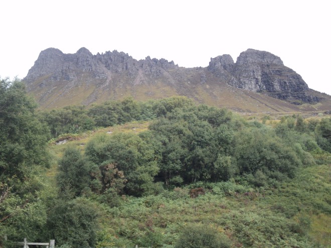 The first objective is the low point on the ridge, about three quarters along to the right. In days gone by, you took a beeline to it from the car park, but heavy erosion of the path (on a mountain that nature is rapidly eroding anyway) led to the construction of a sensible alternative. So now, the path circuits the mountain, and you arrive on the ridge from the rear. I chose to travel anti-clockwise, ie climbing to the right of the photo. (Later – while it was satisfying to complete the circuit – I found the descent route to be pretty boggy by comparison; thus you might consider climbing and returning on the same, drier, route).
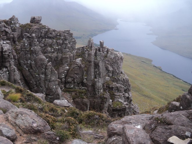 Braver souls may consider a traverse west along the ridge. Well, the reward is increasingly improbable outcrops of sandstone, sculpted into precariously-balanced pillars, and increasingly sensational situations, with severe levels of exposure:
 The flip side is that at several points progress is impossible without a very good head for heights, and the ability to climb and circumvent various rocky obstacles. Having managed to scramble up a steep gully, and then skirt an awkward jutting-out rock, I baulked at “the crux” of the ridge – a 10ft rock tower with a sheer drop of 2000ft on either side. That would have been a step too far for me.

 The sheep on the grassy platform in the middle of the photo gives some idea of scale. Coleridge’s route would have started around here and gone diagonally down to the left, down the numerous ledges he describes, finishing at the visible vertical split in the rock mentioned at the end of his account.


 Returning to the cross, the remainder of the route covers the ground of the Lancastrians’ retreat and ultimate defeat. Late in the day of the battle, Yorkist reinforcements arrived which turned the tide in their favour. This put the Lancastrians to flight, but while the initial phases were fought on relatively flat ground, the line of escape was down into the valley of the Cock Beck. Many of the retreating soldiers met their grisly end trying to cross the Beck (which was swollen by falling snow). From Panels 4 and 5 you view the so-called “Bloody Meadow”, which tells its own story. The Trail follows the edge of the escarpment, so it is easy to imagine the difficulties the retreating soldiers faced.


 Of course, this is