I turned 52 back in early December 2024 and, having notched up a fair number of fell races in the first half of 2025, sometime over summer began wondering if 52 races in a year was possible. One for each week of the year, for each year of my life, for each card in a pack. I kept on track with 12 races in July and August, until my 35th race since the birthday at Burnsall at the end of August. 17 more to do in 3 months.
Perhaps fortunately, some reality dawned to bring this mild diversion to a close. I missed a number of possible races over the August bank holiday week with a family holiday to Suffolk. A nagging sore heel demanded a few weeks’ rest. And the number of races in the calendar dropped off to weekends only, so a further 17 proved beyond reasonable logistics.
A quick fellrunner’s recalculation revealed 42 races in a year as a new realistic target, one for each of the peaks on the Bob Graham Round, as well as being the answer to the ultimate question of life, the universe and everything. I finally limped over the metaphorical finishing line on 8 November at Harriers v Cyclists.
Such mental time-fillers make you wonder what it’s all about anyway, is it a Munro Bagging-style collecting game or do we just race for the fun of it? Obviously, it’s the latter, and I really couldn’t care less how many races I do, as long as it’s as many as possible 😀. Fell races are (for me) the most fun way of going for a run, due to their intensity, engaging courses, pre- and post-race banter, daft prizes, cake, and much more.
So really, this is just an opportunity to say a big thanks to everyone who puts on fell races, in other words those who create and make our sport, purely voluntarily. Race organisers and their clubs, course flaggers, registration/results desk guys, marshals out on the course (aka the hi-viz heroes), cake bakers, prize donaters and more. With an honourable mention to all photographers, video makers, kit providers, spectators and fellow runners who complement the whole. It’s a great community to be part of.
Below are the 42 races I’ve done since 5 December 2024, the majority short and in the Pennines, so just a snapshot of the whole scene. Particular mentions in my case to Wharfedale Harriers (who’ve had a hand in at least a dozen), the summit marshals at The Stoop and Coledale Horseshoe (for braving particularly extreme weather), Ted’s Runners + Riders (for the best post-race spread), Penistone AC (for the daftest prize, a courgette), the Woodentops for photographing so many (including Cowling Gala below), Olga and all the other video-makers, plus our guru Darren of course for inventing this whole fishwicking genre. But actually to everyone involved in them all, and indeed any other past or future race; hopefully see you at another one soon.
Just don’t expect me to organise one myself. Not yet, anyway….
0430: Alarm goes off. Unusually easy to roll out of bed, given the hour.
0545: On the road from Bradford.
0930: Roll into the parking field a quarter of a mile past Penantigi Isaf farm on the A470, 10 miles west of Dolgellau, mid Wales. It’s a big field in the middle of nowhere in mid-October, which can only mean it’s the British Fell Relays. A gathering of the clan where we do our mad fellrunning thing without (hopefully) bothering anyone else. I pay my £10 parking fee and get a relatively flat spot on firm-ish ground, a relief. Load up a rucksack of gear for the day and also grab a camping chair, which may come in useful later. Immediately notice the high, steep mountains to both sides of the valley. Vehicles are now arriving thick and fast, here in this otherwise undisturbed spot, and soon there are hundreds of cars on the field and a mini-army of fellrunners advancing to the start.
1000: Arrive at the North Leeds Fell Runners (NLFR) club tent, after a 10 minute walk which includes a narrow, muddy tunnel under the road. Seemingly miraculously, as if having popped up out of thin air 140 miles from home, 20 other NLFRs are already milling about (we have 3 teams entered), let alone loads of other familiar faces from dozens of other clubs. The multi-coloured tented village is up and running, the banter starts and the cheerful bilingual announcer reminds us we are in the heart of Wales. Before you know it, the Leg 1 runners are going through the kit check tent and into the starting pen.
Tented village and finish, with some gentle slopes beyond
1100: I’m on (navigational) Leg 3 of the men’s open team (we also have women’s open and V50 teams). On Leg 1 my team has Tom B, this year’s BOFRA Championship winner, and the Leg 1 route looks similar to a BOFRA course, only even steeper and longer. Josh and Phil on Leg 2 are primed for an early handover. 190 runners are underway on the 11am mass start with Tom near the front. In fact he makes it to the top in 3rd place and is back in 32 minutes, just 2 minutes behind the first runner. From the handover, Josh and Phil now have a very different leg, about twice as long, so it’s more uncertain for us on Leg 3 to predict when to be ready.
1200: I decide to sort-of start getting ready and wonder why my shoes don’t feel very tight. Closer examination reveals the soles mostly departing from the uppers, don’t ask me how I hadn’t noticed earlier. Decide there is time to jog back to the car to get a spare pair; I have a graveyard of various old running shoes kept permanently in the boot. After trying several pairs, I realise none are in better condition than the original. So it’s time for Plan C – the Pete Bland van. Fortunately it’s here, has a pair of size 12 wide-fit Mudtalons, and reception for the card machine. 80 quid, fair enough, you’re going to need a new pair before long anyway…
1230: The first Leg 2 runners come in and hand over to their Leg 3 counterparts. On Leg 3, you don’t know where you’re going until someone gives you a map 5 minutes in. Speculation on the field was that it would be on the other side of the road, and indeed we can see the nav pairs run through the muddy tunnel and up the hill beyond.
1245: The worst thing you can possibly do on a relay is not be there for the handover when the previous leg runners come in, so Will and I on Leg 3 go through kit check and into the holding area. So, just have to stay warm somehow until Josh and Phil come in, which could be any time from now. Will seems very relaxed, which I’m pleased about because he’s had the unenvious job of pulling the team together, including having to find two last-minute replacements (of which I’m one). We jog about a bit while trying to keep an eye on the Leg 2 pairs arriving. They all look like Josh and Phil from a distance… until eventually Phil’s distinctive red shorts come into view and we’re ready to go.
Warm up area looking cloud-wards
1315: Will and I are underway, through the tunnel and shortly after handed a map each, showing 9 checkpoints to visit in order. However, conditions are clear and we’re midway through the pack, so other pairs are strung out in front of us. The nav is thus no problem; instead, I get to concentrate on the running side of things. Namely that Will is much faster than me, it’s a lot of uphill (or contouring) and conditions underfoot are very rough (heather, tussocks and bog). It feels very hard and unremitting and apart from dibbing the checkpoints I don’t get any kind of breather.
1415: After what seems like an eternity Will and I get to the penultimate checkpoint on what must be the final hill. Downhill all the way from here, surely. The descent includes our one small bit of nav, contouring round a final bump rather than going over, which I’m extremely grateful for. We belt it down through the final fields, into the muddy tunnel and…. then the sting in the tail. Rather than running straight into the handover area, we have to do a lap of the field. This includes a miniscule climb, but it feels the worst of all. As we eventually go through the finish my legs turn to jelly and I wobble through the dibbing area and back to the tent. Can’t remember the last time I pushed so hard for so long, 1hr 23 minutes as it turned out.
1430: We handed over to Tom S on Leg 4, which is similar to Leg 1, but my thoughts are focused on collapsing into the camping chair, thank goodness I bought it. Niamh then informs me about some showers on site and that seems like a good idea, so after a bit more rest I find these and it really was a good idea. Refreshed, I think about some food but the queue is snaking round the field and anyway I can’t find my meal ticket (which I’d thoughtfully removed from my race number earlier). So it’s back to the club tent for snacking, cheering in the Leg 4 guys, taking photos and generally recounting and recovering. Will looks like he’s barely broken sweat.
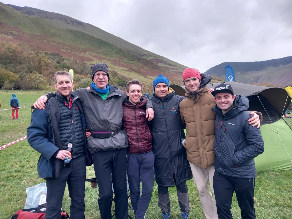
NLFR men’s open team jacket models – Josh, Dave, Tom B, Phil, Will, Tom S
1630: All three teams are successfully round, a great club effort given the tough terrain and distance from home. We start noticing the cold, the tent comes down and the trudge off the field begins along with everyone else. It’s taken the host club, Merionnydd, 12 months to organise this gig, and most of us have only been on the field for 6 hours.
1730: Arrive at our accommodation for the evening, 20 minutes drive along the road, a further 10 minutes up a long winding track. There is parking for 2 cars, but by some significant error in car sharing there are in fact 7 cars, for 9 people. And no turning space. Somehow, we all find a spot, and organise 2 cars in such a way that we can easily drive off to the pub in the dark later.
The environmental sub-committee meet to discuss the club car sharing policy
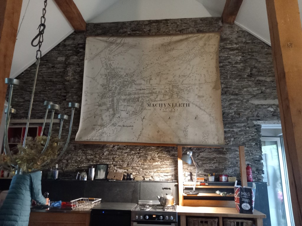
The Airbnb is somewhere between a bunkbarn and a fancy conversion, with distinctive features like a woodburner, a sunken bath, a raised outdoor platform and a gigantic historic map of Machynlleth. But all thoughts are turning to the pub…..
No central heating but it does have a giant map
1900: Arrive at The Brigands Inn, Mallwyd, where we are booked for dinner. Thank goodness I ordered 3 courses in advance, I’ve not had a square meal all day. All 20 of us are put in a side room out of everyone else’s way, the service and food are excellent and it’s a great way to end the day. Thank you Brigands.
1030: Arrive back at the Airbnb. As a late addition to the booking I don’t get a bed, or a sofa, but after a day like that a bit of floor for mat and sleeping bag is more than adequate. Fell Relays day is always like two days in one!
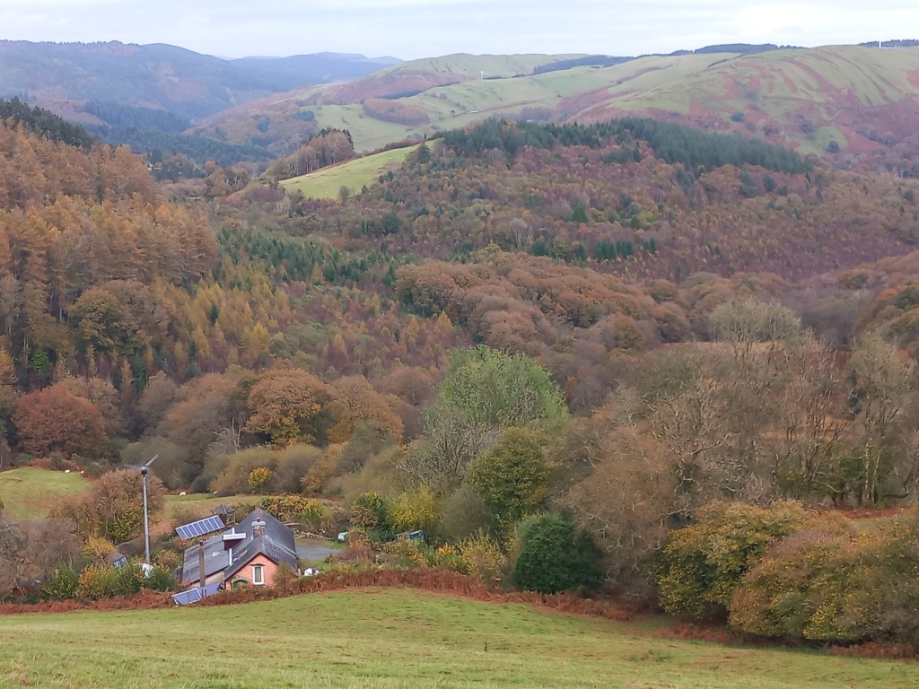
Back in October out on a walk I passed this scenic spot in mid-Wales, a remote house boasting a distant view. Peaceful now and equally in early 1970, when it was rented by Robert Plant and Jimmy Page, recuperating from a crazy 12 months that had seen their new band – Led Zeppelin – become the biggest in the world, seemingly overnight. That winter they worked on new material that became their third album, including two songs named after the house, Bron-y-aur. They also started on another number that later did quite well, Stairway to Heaven.
Since that October walk I’ve been taking a deep dive into the impressive Zeppelin back catalogue, and this week caught a fab new film, Becoming Led Zeppelin, that documents their whirlwind 1969. You can see why they may have needed a few months chilling out in the middle of nowhere after that.
Some reviewers of the film have criticised its limited scope. It stops 18 months into the life of a band that continued for another 10 years. But for me, this is the film’s strength. The focus is almost exclusively on the amazing music, and how the four members gelled from the off. Everything in the film is positive, with any later controversy conveniently left out. R + R without the s or d (or occult, violent managers, untimely death of members etc etc). This is Zeppelin you can take the grandkids to watch.
Some of the early footage is amazing, and shows how unprepared people were for what they were about to hear. An early concert in Denmark where the audience comes in and sits on the floor in front of the band, as if they’re coming into a school assembly. Another with mums and babies watching, covering their ears. Later footage shows them relentlessly touring around America, where things really took off. The best performance is this one of Dazed and Confused, with Jimmy Page’s trademark playing of the guitar with violin bow, very avant garde!
The three surviving members of the band are all interviewed and come across well. Jimmy Page, who dreamt up the idea of the band and executed it ruthlessly, recollects everything in minute detail. Robert Plant quite avuncular, seemingly still pinching himself that he went from obscurity to stardom so quickly. Equally John Paul Jones, softly-spoken ex-choirmaster who found himself in the world’s biggest rock group. And perhaps the movie’s strongest feature, a previously-undiscovered audio interview with drummer John Bonham (who almost never gave interviews and died in 1980) – this is integrated into scenes to some effect, and makes you feel that the whole group are telling their story on their own terms.
As an added bonus, I went to see the film at the IMAX. Zeppelin have a huge sound and an arresting image, so this is how best to see and hear them. Go and do so while you can!
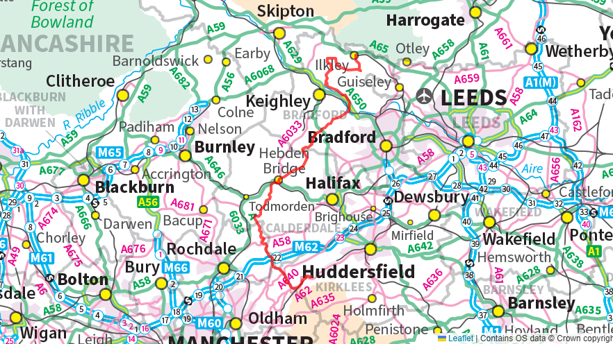
Linking the Stanza Stones in one continuous journey
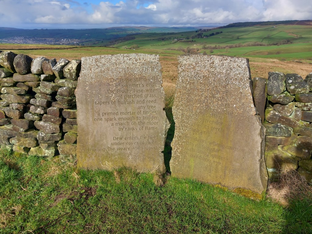
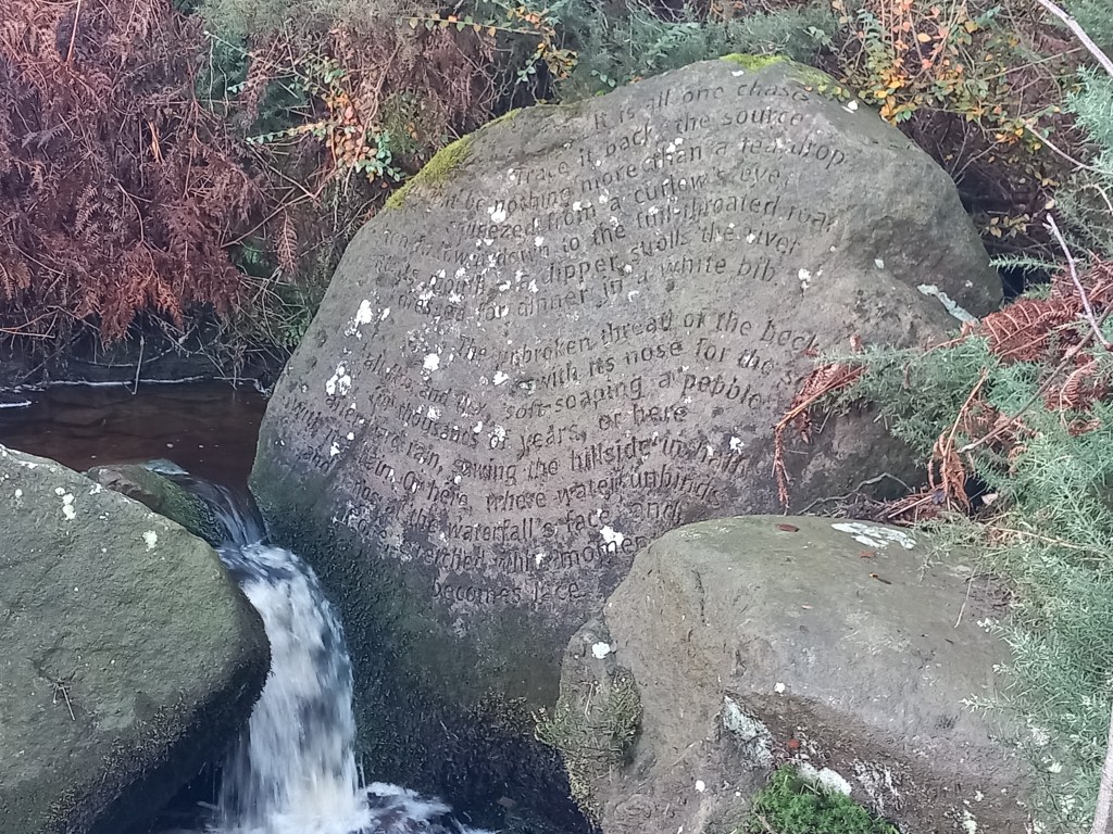
Over the last few weeks I’ve been filling in the pieces of an outdoor jigsaw puzzle. Namely, visiting all of the so-called “Stanza Stones”, six poems by Poet Laureate Simon Armitage carved into rock on the South Pennine Moors. The stones are located between Marsden (where Simon grew up) and Ilkley (Ilkley Literature Festival originally sponsored the project). Each poem is based on water in its various physical states – Snow, Rain, Mist, Dew, Puddle and Beck – and there’s plenty of all up here at this time of year. The rocks themselves are variously quarry walls, existing crags and boulders, as well as stones transported to site. Some are very prominent, others more difficult to locate. It’s been like a mini-treasure hunt tracking them all down, but eventually I found all six:
DewMistRainBeckPuddleSnow
There’s much to take in here – the poems themselves, their placing, the use of materials, the style of carving, how they all relate to the landscape/local area etc – all of which are potentially quite thought-provoking. However I will focus now on one specific aspect, namely the various ways in which you could link all six in one continuous journey.
As the crow flies (according to freemaptools.com) it’s 23 miles from Marsden to Ilkley, both of which are served by train stations, so immediately the idea of a route between them via the Stanza Stones seems possible. In fact, there are already three published routes that do just that:
Firstly, there is the original “official” route published by Ilkley Literature Festival, 47 miles in total (so obviously it must wind about a bit). It follows the Pennine Way to Hebden Bridge, then cuts north east to Bingley before a circuitous route around Rombald’s Moor to Ilkley.
An alternative Stanza Stones Walk has also been published by Mick Melvin, building on the literary theme by visiting Mytholmroyd and Haworth as well, homes of Ted Hughes and the Brontes respectively. This route adds a few miles to the original so it’s nearer 50 miles in total.
Lastly, there is now a Stanza Stones 50 mile Ultra, first organised by CraggRunner in 2023 and set for its third running on Saturday 7 June 2025. This route combines elements of the previous two with 5 checkpoints. With a 9am start you have 24 hours to complete the 50 miles with 6800ft of ascent. Entry is available here for £58-£70, minimum age 20 years.
Of course you don’t have to follow published routes, and it would be fun to come up with individual variations. If the straight-line distance beginning to end is 23 miles there must be scope to shave a bit off 47-50 miles! I quite like devising running routes with a loose “theme” of sorts, so if I come up with a good alternative of my own I will share it here.
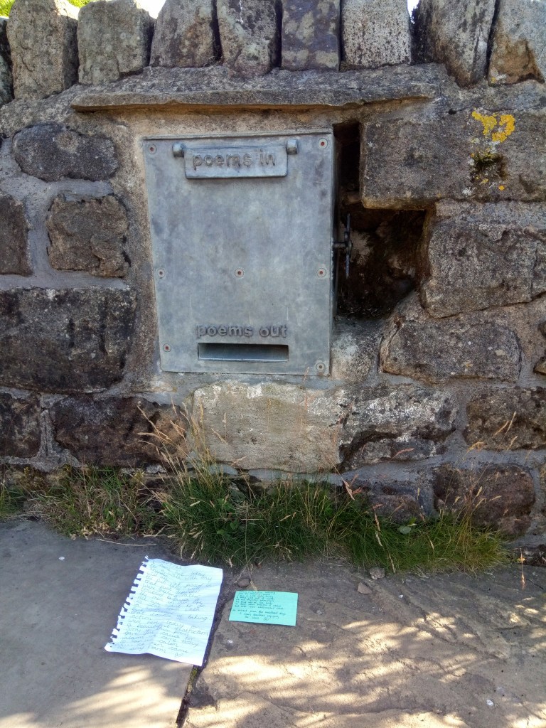
As an added bonus, between the Puddle and Beck Stones on Ilkley Moor you pass the Stanza Stones Poetry Seat at Gill Head, colloquially known as Poetry Corner. Here you can contribute poems of your own by posting them in the postbox-like “Poetry Box”, and with a crank of the handle reaveal others previously-contributed. You get a nice mix of stuff in here, mostly funny or a bit rude, it’s all good fun. Here’s a couple I’ve liked previously:
More information about the Stanza Stones project, including the poems themselves, can be found here. My favourite is “Rain”, quite possibly because it was hoofing it down when I visited, freshwater tears indeed…
Be glad of these freshwater tears, Each pearled droplet some salty old sea-bullet Air-lifted out of the waves, then laundered and sieved, recast as a soft bead and returned. And no matter how much it strafes or sheets, it is no mean feat to catch one raindrop clean in the mouth, To take one drop on the tongue, tasting cloud pollen, grain of the heavens, raw sky. Let it teem, up here where the front of the mind distils the brunt of the world.
There are two ways of looking at the Borrowdale Fell Race. One is to say this is a very difficult race, in an extreme environment, so unless you’re super good you frankly shouldn’t be bothering with it (how long can you reasonably expect marshals to wait at the top of Dale Head for you?). The other is to look at the two cut-off times – 3 hours 20 minutes at Sty Head, 4 hours 30 minutes at Honister – and if you think you can hit them, then it’s a challenge you’re entitled to take on. At present, I’m in the latter category, and despite my obvious limitations as a long-distance fellrunner I recently completed my fourth race out of four attempts (2019, 22, 23, 24). So here are 10 tips from my experience to encourage other run-of-the-mill fellrunners, who may be intimidated by the prospect, to give Borrowdale a go.
Make it the focus of your summer:
The race is always the first Saturday in August, which gives you a few months of summer to build up to it. I did my first longer run in the Lakes this year at the Fairfield Horseshoe (AM) in May, moved up to the Buttermere Horseshoe short course (AL) in June, then a long run in the Dales in mid-July.
Recce the course:
I was lucky enough to spend the summer of 2019 in Borrowdale so was able to become familiar with the route. I didn’t enter that first time until I’d fully recce’d the course within the cut-offs. So much can be gained from learning the course – terrain, navigation, lines, water fill-ups etc, and just knowing what you’re letting yourself in for. Be particularly wary of the risk of visiting Base Brown when traversing around Green Gable, an easy trap in mist.
Train rough and long:
At 17 miles with 2000m of ascent obviously you need endurance, but perhaps more importantly at Borrowdale is the ability to run on rough ground, because that’s what you get the whole way round. Keep to the fells in the build-up, the rougher the better.
Plan it around the cut-offs:
I mentioned the 2 cut-offs earlier, miss them and you’ll be directed back to the finish and be DNF’d in the results. The key is to pace things so that you’re comfortably within the cut-offs, so you’re not worrying about them and to give you flexibility in the event of the unexpected. This year I hit Sty Head in 2:48, Honister 4:00, about right. Once through Honister, you can tackle Dale Head in whatever time you wish!
Break it down into 8:
The race has 8 checkpoints you have to dib and your splits are presented in the results. I find this quite useful in terms of visualising the race, breaking it down into 8 individual sections, each of which is its own mini-challenge:
1: Start to Bessyboot – flat initially then steep climb
2: to Esk Hause – lengthy undulating trods
3: to Scafell Pike – gradual climb, increasingly rough including boulder-hopping
4: to Sty Head – initial steep scree descent, then descent along/to side of Corridor Route
5: to Great Gable – steep climb
6: to Honister – undulating descent on rough ground
7: to Dale Head – steep climb
8: to finish – steep descent on rough ground
Take it easy the days before:
In my mind, the only things running can really do for you in the days before a big race is get you knackered or injured. This year on the day before I took the day off work, watched the Olympics and got my stuff together, ideal.
Get there early:
Start time in Rosthwaite is always 11am, it’s nice to arrive early to get your number and gear sorted and, more importantly, get some decent banter in with anyone you know, which I find really relaxing – takes your mind off what’s ahead!
Start slowly:
Within 200 metres of the start you’re faced with a major bottleneck where the course joins the Cumbria Way. So start slowly, let the fast runners go through, and accept the 2-minute “delay”. It’s actually a blessing in disguise, slows you down when the adrenaline may be running high.
Be ready for changes mid race:
The sun may be shining when you set off, but it can all be very different on the summit of the Pike 2 hours later! Obviously you have to take minimum FRA kit but be prepared for rough conditions, the need to navigate etc. This year I set my compass to the bearing off Great Gable pre-race and indeed needed to use it.
Recover after:
The DOMS are likely to be bad so don’t be afraid to sit in the river after or do a gentle recovery walk/”run” the following day. And reflect on how it all went, this may increase your chances of coming back to do it all again in following years!
My Borrowdale times (so far):
2019: 4 hours 19 minutes
2022: 4:22
2023: 5:23
2024: 5:07
Climbing Great Gable, 2023. Photo: Grand Day Out Photography
Over the last couple of months I’ve been working my way around the Calderdale Way in various stages, 50 miles or so in total with 2500 metres of ascent. The original idea was to do it in 6 stages, clockwise, to correspond with the format of the Calderdale Way Relay in May. This would mean driving to each start point and, having completed each leg, returning there either on foot or by public transport. I’ve previously ticked off completions of the Leeds Country Way and Bradford Millennium Way, so Calderdale felt like the next obvious circuit to tackle. I was also inspired by reading various books and maps by Chris Goddard, which really bring the area to life and I highly recommend. Here’s how I got on:
Sun 24 Jan 2024: Shelf to Salterhebble return, 26km, 715m (Leg 6)
I chose to start at the point of the CW closest to my home in Bradford, namely Shelf to the east of Halifax, mainly to minimise driving. Confusingly, this meant that my first run was going to be Leg 6 of the relay route, the second run Leg 1 and so on, finishing with Leg 5. Well, it made sense in my head.
Initially, a 20-minute drive to Shelf early on a Sunday morning. Ideally I prefer quiet car parks over parking on the street, particularly at this time of year – gives you a bit more space to change your socks and bang your shoes at the end of a muddy run. Shelf has such a car park, but a sign saying it would be locked at 4pm put me off, so the main road it was. I’m a bit of a pessimist and didn’t want to fret about some random delay getting me back late, running is much about letting stupid worries in life drain away.
The first bit was generally downhill towards Brighouse, through woods and fields. Last time I was here was 2006, running Leg 6 for Valley Striders in the relay. It was a December event then – leg partner Steve and I set off with the mass start at 2pm and got to the finish in the dark, no headtorch. I remembered bits and pieces of that as I went along. Midway I weaved my way through the streets of Brighouse, onto the canal, past the impressive flour mill/climbing wall, up through some woods and then more road. In fact, I was to find that the CW overall has a surprising amount of tarmac – perhaps 10% of the whole route – although this did provide some relief from the otherwise incessant mud.
A very bad bit of road came at Salterhebble where they’re building a new stretch of highway. Roadworks blocked the pavement that you’re meant to run along, so I had to take my chances dodging traffic and cones in a contraflow system. Better was the return to Shelf via the Hebble Trail into Halifax, then climbing Beacon Hill and back via Shibden Park. I had a quick look at Shibden Hall (closed for winter), 19th-century home of Anne Lister, famous for her 4 million-word private diary written in code (now cracked and translated). Eventually back to the car with half the mud of Calderdale attached to legs and shoes, this was to be the theme from now on.
Sat 3 Feb: Salterhebble to Cragg Vale, 33km, 670m (Leg 1)
I pulled up at another car park with a suspicious-looking gate, next to the canal. No off-putting signs this time though, so I risked it.
A mile along the road, into the woods then immediately lost the route, adding half a mile. The first of a few similar errors all-told. I was relying for nav. on the paper OS South Pennines map, which wasn’t always clear or easy to keep dry.
Above North Dean Woods I passed close to Stainland Rec, which according to Chris used to host games of “Knur & Spell”. A bit of googling later revealed this to be a quaint Yorkshire tradition, colloquially poor-man’s golf. The idea being to smack a ball suspended in a sling as far as possible with a wooden club. It was also played in Barnsley, and contests used to be described as the world championships. There are a couple of unintentionally-hilarious old videos on youtube that are beyond parody. Much better than real golf.
Onto Norland Moor, an unusual flat expense of heather on high ground. Approaching the edge, a cold wind and lashing rain really swept in. The next bit to Ripponden was just survival, but there was some respite once down in the valley.
Further on I found more shelter on top of the next moor, in what appeared to be something like a wartime pill-box. In fact, Chris reveals it to be a WW2 bombing decoy bunker, a so-called Starfish site. Fire and light displays on the moor were coordinated from here to divert German bombers from their intended urban targets. There’s no great evidence these were successful, but their existence says much about those times.
Finally, descending to Cragg Vale the battering from the weather relented and the return jog was surprisingly pleasant. Initially down the valley of Cragg Vale itself, full of lovely woods, a lively river and interesting early-industrial remains. Then along the canal from Mytholmroyd – a bit of a long drag but a quick off-road return to base.
Quite a straightforward leg this, along a mile of road to the reservoir, up and over the moor to Mankinholes, then down through the fields to Tod.
I quite like the bit by the reservoir as back in 2002 I had a fellrunning “Road to Damascus” experience here. I had just moved to West Yorkshire and was out for a solo ramble in January, getting increasingly cold, when a fast runner came past me from behind. He was followed shortly after by another, and turning I saw a field of 100 more on the way, a fell race no less. I immediately thought that looked much more fun than getting cold in walking boots, joined a fellrunning club shortly afterwards and have never looked back.
Another bit of reminiscing came later on, passing YHA Mankinholes. I was employed by YHA from 2019 to 2022 and my time there included a week looking after this hostel. It was a doddle really as I just had to clear up after one group left and get the place ready for another arriving. But it was one of many hostels YHA put on the market last year, so it may not be a YH much longer.
It had only taken an hour to get to Tod and I was weighing up how to get back to Cragg Vale. My first thought was to quickly look in at the station and see when the next train to Mytholmroyd was. Answer – it was on the platform, so having confirmed with the assistant that I could buy a ticket on the train I jumped on. The train passed through Hebden and I motioned to get off at Mytholmroyd. The train sped straight through, and didn’t stop until Halifax. On the platform the assistant asked me what I was doing there, why hadn’t I changed at Hebden? Pleading ignorance I asked for advice. Get on the next train to Brighouse, then change. An hour after last seeing Mytholmroyd, I eventually alighted at it. The jog back up Cragg Vale lightened my mood.
Sat 2 March, Todmorden to Luddendenfoot, 33km, 940m (Legs 3 + 4)
This turned out to be much the toughest outing – length, climb, weather, underfoot conditions. Ironically, it was the one I felt best on, and decided to extend further than originally planned.
Rather than finding a spot in Tod itself, I parked in the free car park by the main road a mile out of town, and jogged in along the canal. I passed a community allotment (there’s a lot of that kind of thing in Calderdale) with a sign warning “Trespassers will be Composted”. I should have taken a photo of this rotten gag – nearly 30 years ago my first paid job was to encourage people to make compost and I still have a bin at home.
The CW makes a slightly unnecessary loop around Tod, bringing you out about a mile up the road after 4 miles and a big hill of effort. Another long climb brought me out onto more exposed terrain, with snow flurries and a churning mix of snow and mud underfoot. Progress was snail-like through this. But things got a bit easier around Heptonstall, which had been a possible turn-around point, and I found myself carrying on down to Midgehole. Again, I gave turning around some thought but chose to press on, perhaps thinking I should get this CW thing boxed off while I’m here rather than plan too many more wet and cold days out. Up top I skirted the edge of Midgley Moor. It felt a bit 50-50 to be up there in these conditions, but if I wanted to bail I could be off in just a few minutes. It turned out OK though and eventually the CW drops off the moor to Jerusalem Farm, where I finally decided I’d had enough. A 2 mile jog down the road brought me out at Luddendenfoot. The bus stop showed just a 10-minute wait, and 15 minutes after that I was back at the car. Public transport’s great when it works.
Sun 17 March, Shelf to Booth, 16km, 450m (Leg 5)
So, just the final leg to go, Jerusalem Farm to Shelf. My original plan was to do it as a there and back from Shelf, so I could say I’d done the whole thing in a clockwise direction. But this day didn’t bode well for such a long run. I was nursing a sore hamstring and the weather remained drizzly. I set off from Shelf gingerly, walking mainly to start with and jogging the easy bits. Normally, things get easier once you’re underway but events contrived to chip away at my enthusiasm. The mud was glutinous and I made one, then a second route-finding mistake. I didn’t really have the heart to go back and follow the route-proper, which was fiddly and erratically marked. For much of the CW you see the familiar waymark logo and could almost navigate without a map, but there are stretches where it’s not obvious at all, such as this. It took 2 and a half hours to do the 10 miles to Jerusalem Farm, and I wasn’t going to turn round and repeat it. This time, I walked up the hill to Booth and found a bus was due in 15 minutes. This gave me time to get my leggings and shoes off and make myself presentable. The bus took me round the houses but eventually to Halifax, where I changed for one back to Shelf. I was content this meant I had now completed a full circuit of the Calderdale Way.
To sum up….
The CW is a challenging route, up and down over mixed terrain of moors, fields, tracks and tarmac. I did it at the most difficult time of year, often in cold and rain and with plentiful mud underfoot. Route-finding is often straightforward, but not always (anyone doing the Relay in May should certainly recce their leg in advance). The scenery is generally very good and there’s much of interest on the way. Shops and places of refreshment are available on the route itself most obviously at Brighouse, Ripponden and Todmorden. The valley’s bus and train links give good options for doing circular ventures, with the route passing close to the train stations at Brighouse and Tod.
I mentioned at the start that I’ve previously done the Leeds Country Way and Bradford Millennium Way. By that I mean I have completed both of those in several stages first, before doing a full circuit in a single day. Doing the Calderdale Way in a single day would be noticeably tougher, and at present it feels well beyond me. Saying that, others have done it…..
Coincidentally, a few weeks ago Chris published a map of the CW, which is a nice momento of the route and full of detail about points of interest along the way – available on his site for £6.99. It would also be good for route-planning; I’m sure spring and summer on the Calderdale Way are nicer than the conditions I encountered, there won’t always be all that mud.
A quick preview of 7 local fell and trail races coming up this month:
Sat 4 Nov, 1pm: Shepherd’s Skyline – 6 miles, 350m climb, £6 EOD, HQ Shepherd’s Rest Inn nr Todmorden. A nice run along the skyline to Stoodley Pike, a steep drop, a climb back up and a final descent. Bogs, rocks + pub, what more do you want.
Sun 5 Nov, 10.30am: Cop Hill – 6 miles, 275m climb, £5 pre-entry or EOD, HQ Meltham Sports Centre. More hilly multi-terrain than fell but still a good race on a 2-lap course.
Sat 11 Nov, 10.30am: Post Hill Challenge – 5.6km, £8 pre-entry, HQ Troydale Social Club. Undulating 2-lap course featuring 2 climbs of the (in)famous Post Hill; not technically a fell race but it feels like one – pace it carefully. If you think this is daft, compare with 1920s-style racing on Post Hill.
Sat 11 Nov, 11am: Holly Hustle – 7 miles, £15 pre-entry, HQ Meanwood Institute. Going head-to-head with Post Hill, Adam has lined up plenty of mud for the 5th running of this Great Owl trail race up + down Meanwood Valley.
Sun 12 Nov, 11am Wadsworth Half Trog, 9 miles, 420m climb, £6 pre-entry or EOD, HQ Hare and Hounds Pub nr Hebden Bridge. Not done this one but any race with the word “trog” in it can only mean mud, bog and perhaps some more mud.
Sat 18 Nov, 10.30am, Tour of Pendle, 17 miles, 1500m climb, £10 pre-entry by cheque (yes, still). HQ Barley Village Hall. My 3 top tips: i) expect to park half a mile from the start, ii) pack a £10 note for tea and cake after, iii) the race doesn’t start until you’re about 10 miles in. Not for the faint-hearted, enjoy.
Sat 25 Nov, 2pm, Harriers v Cyclists, 5 miles, 300m climb, £10 pre-entry, HQ Bradford & Bingley Sports Club. 100 runners and 100 cyclists jostle it out together through the mud, up Shipley Glen to Baildon Moor and back. A whole lot of daft fun in what will be my final fell race for Valley Striders before switching to NLFR, hope to see a few of you there (and perhaps for refreshment after).
Just want to say a big thanks here to everyone at North Leeds Fell Runners, who’ve all been so welcoming at the Tuesday night training sessions I’ve tagged along with this year. I’m pleased to say that (finally) I’ve joined NLFR 2nd claim and look forward to being involved in the club.
I’ve been a 1st claim member of neighbouring club Valley Striders for 8 years now. Valley has a fair sprinkling of fellrunners in its ranks, with the trend amongst members being towards increasingly challenging and exotic fellrunning adventures. There is less though in the way of regular training sessions or meet-ups at local races, so that’s why it’s been nice to try things out with NLFR, where this is more established. Many thanks guys for the warm and relaxed welcome to the club.
As that suggests, I do quite like a local race and it’s been nice to meet some fellow, er, enthusiasts from NLFR at races this summer – Jack Bloor, Coiners, Crow Hill, King’s Challenge, Burnsall and (yesterday) Malham Show included. Just to mention I’m potentially available to offer lifts to races if it’s not too far out of my way (I live in Bradford). Eg last week I gave Jonny a lift to Burnsall from Ilkley train station; in return he paid for the parking, let me beat him in the race by 4 seconds and didn’t mind when I dropped his skyer in the egg-throwing competition – a fair deal all round.
Elsewhere on my blog are write-ups of various races I’ve done and I often like giving good ones a plug. While many were off at the champs race at Sedbergh last weekend, I tried the lower-key Crowden Horseshoe for the first time. I had it in my head this would be a proper Dark Peak bog trot so wouldn’t be too harsh on my legs, still sore from Burnsall the day before. I also wanted to escape the moral dilemma, on the morning of the World Cup final, of having drawn Spain in a sweepstake.
Turned out I reckoned wrong on both counts! The 11am start at Crowden campsite coincided with kick-off in the footy, which was broadcast loud and clear to us over the radio. Once underway, the race route was surprisingly technical, calling for much more twinkled-toed rock avoidance than anticipated. Good job conditions were fine and the long descent back from Black Hill so scenic, helped keep my mind off the aching legs. Went straight from the finish to the river and sat in it for some time, nature’s own ice-bath treatment. Came back to a slightly downbeat campsite, Spain having won the final and I was now, awkwardly, £50 richer. After wrestling with it on the drive home, I donated my winnings to Mountain Rescue. Happy to have done that, after all I might have needed them if that race had been much longer!
In preparation for a forthcoming club Bob Graham weekend I’ve been trying to get to know the BGR route better, both my own allocated leg (Leg 3) and, in case of last minute changes of plan, other sections not previously visited. A couple of weekends ago this had me and pal Simon recceing Leg 3. The good news – we got round the full leg; the bad news – it completely exposed how poorly prepared I was for taking on a challenge like this. Most obviously I just didn’t get the food and drink right, both out on the fell and in between. I was struggling by the end, so lessons to be learned!
With fresh resolve I decided to have a look at Leg 2 this weekend, a leg I’ve not done before. After the Leg 3 debacle I thought it was sensible to break it down into sections rather than tackle it all at once. By happy coincidence, my old club Keswick AC were putting on their annual Helvellyn and the Dodds race on Saturday, which covers the first half of the leg. This would then give me the rest of the Bank Holiday weekend to look at the remainder.
The race starts at Threlkeld Cricket Club, traditional handover point between Legs 1 and 2 on the BGR. Please note they’ve just put in a parking meter – £3 in coins or by parking app. Parking apps give me a nosebleed, particularly in remote areas with poor coverage, and I didn’t have any coins; fortunately a friendly face was on registration, my old colleague Catherine. She didn’t have a lot of change but we struck a deal of 3 pound coins in return for my £20 note; with entry being £14 that put Keswick AC £3 to the good, but it seemed a small price to pay for a technophobe like me!
Cat also gave me the top tip of watch out for the climbs on the way back. This was helpful as it seemed difficult in advance to work out this race. In one way it seemed pretty straightforward – climb up onto the ridge, run along it for 5 miles, come back the same way. But it’s still an AL fell race which means it must be hard, one way or another.
The other useful bit of intelligence was that there was no water on the route. This meant that my new filtration water bottle (ref. Leg 3 debacle, above) wasn’t going to be much help, so how much to take? Conditions were fine, but blissfully cooler than forecast earlier in the week. With the course record being 2 hours I reckoned I’d do well to get in under 3, so took about a litre, along with an apple, a piece of flapjack and some almonds. Full kit was enforced which meant quite a heavy rucksack but I was happy to err on the cautious side, this was just about getting more experienced at negotiating a long run. Meanwhile I looked at those with seemingly tiny loads with some wonder.
Race start at 11am and a jog along the tarmac for the first half mile, before hitting the open fell. Before long, we were walking up the steep grass steps of Clough Head. Already I was beginning to factor in how it would be coming back – this is a tough climb, but the descent in 3 hours’ time will be worse! This climb must be hard when you’re doing the BGR for real – Yewbarrow I guess is the only one that compares for continual steepness and height?
Eventually we topped out to the first checkpoint, followed by a long downhill to a depression (but yes, we will have to climb this on the way back). Up to the second checkpoint at Great Dodd; with an hour gone I had my first food and water stop. I was fine with taking a minute or two here, I don’t much like eating and drinking on the go and the views across to the central Lakes were stunning. In fact with the ground underfoot not too technical it was possible to take in the views much more today than other races I’ve done, where a quick scan of the horizon can so easily be followed by a trip.
From here the next checkpoint is Raise, which means the best line skirts the BG tops of Watson’s Dodd and Stybarrow Dodd. Mental note to navigate carefully here on a BG day, particularly at night/in mist. Just before the summit of Raise the mildly depressing sight of the leaders returning the other way. Some more ups and downs via White Side and Helvellyn Lower Man until eventually reaching the cheerful marshals on top of Helvellyn, celebrated with my piece of flapjack. 8 BG tops visited in less than 2 hours, if it was all like that we’d be doing it in 10 hours!
Still, it seemed a long way back, but fortunately my legs were still moving OK on the descents and the climbs, although long, were manageable. I got a lesson in proper fellrunning though from an older guy from Keswick – while I kept overtaking him on the climbs he was coming past on every descent, having picked the perfect line. Eventually, back to the top of Clough Head. I finished off my food and water, took a complimentary sweet balanced on top of the trigpoint and began tentatively descending the steps. Several proper fellrunners stormed past as I tiptoed down, but as long as I was moving I was fine about it. Eventually back to the tarmac and a more comfortable run in, feeling more like a closet road runner than a fellrunner. Back in just under 3hrs 15mins, 49th of 102.
If I’d had a niggly sense that £14 (£17) was a bit steep for a low-key fell race I soon found out it was an absolute bargain. A huge spread of free sandwiches, cake, juice and tea was laid out, and I didn’t miss out. In fact, many of us were still there an hour or two later, enjoying the sunshine, shared experience and hospitality – thank you Keswick AC!
As a postscript, seemingly well fed and recovered I returned the day after to have a look at the rest of the leg. The plan was to go up Helvellyn from Dunmail then return via the BG route. But the climb was surprisingly hard work, and while admiring the view of Striding Edge the apple I was eating almost slipped out of my hand; good job it didn’t as it would have ended up in Red Tarn 1000 feet below! I took that as a sign that maybe Fairfield and Seat Sandal were best left for another day. It’s one thing to do short/medium fell races, but this longer and multi-day stuff is a whole different order. Still more to learn, I’ll be pondering that while watching the footie with my feet up this afternoon!
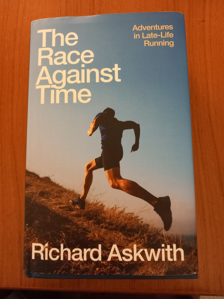
Review of “The Race Against Time – Adventures in Late-Life Running” by Richard Askwith
Once a decade it seems Richard Askwith writes the definitive guide to keeping running interesting as you grow older. 2004’s “Feet in the Clouds” saw him escape from chasing PBs on suburban pavements to finding the freedom of the fells. A decade later, in the rural Midlands, 2014’s “Running Free” thought even more laterally about how to connect running to nature, whether it was by inventing running games in which you got deliberately lost or were voluntarily chased by a pack of hounds. And now in 2023 he has completed a trinity – “The Race Against Time” is a hugely upbeat and positive presentation of what running can do for you in even-later life, right up to the age of 100+ (if you’re lucky enough to get that far).
The book sticks to a trusted formula of generally surveying the so-called “Masters” scene (interviews with some of its leading figures, exploring the science of ageing etc) alongside the author’s own experiences. As someone who’s just turned “the wrong side of 50” there is much to be optimistic about here, not least how running can significantly improve your quality of life and independence in your later decades.
A recurring theme in the book is that you need to train smarter as you get older, with a greater focus on fewer, more intense workouts with greater recovery…. rather than just daily steady running. Not least to slow the rate of inevitable decline in muscles, the nervous system etc as you age. I particularly liked the analogy on p.220 in conversation with coach Pete Magill about how to avoid injury by varying your training:
“It’s like having a garden and you only water a third of it. And then the next day you only water the same third, and then the next day, and the next. And then you say – why is two thirds of my garden dead, when I water it every day?”
This sounds encouraging to me, as a fellrunner. My average “fell run” at the moment has unconsciously evolved into a walk/scramble up a hill to start, a jog along the top with several stops to take in views, have a chat/bite to eat, have a swim etc…. then an eyeballs-out descent back to the start. In other words, during a 3-hour “run”, I might only be running fast for half an hour. Meanwhile, running on the uneven terrain of the fells builds up strength all over your body. Mixing this with regular (and generally shorter) races and touch wood, I’m in reasonable shape at the moment and more importantly, really enjoying my running. (And ironically, since ditching a deliberately “competitive” mindset, I’ve been going a bit faster, and certainly getting injured less).
In fact if there’s one obvious gap in the book it’s that our fellrunning guru doesn’t focus more on the exploits of older runners on the fells. There are inspiring achievements by fellrunning “Masters”, whether the more obvious ones like Ken Taylor (first Bob Graham completion by a V70) or the evergreen Wendy Dodds, to more humble figures like Trevor Metcalfe (only V70 completer of this year’s BOFRA series of short-but-tough races) or my club-mate Steve, still entering AL Fell Races as a V70. We will all know similarly inspiring role-models.
You would have thought that a new running book by Richard Askwith would have been preceded by a bit more of a splash, but this one has sneaked out at quite short notice. Nonetheless, with the wind howling as I type it’s come at a good time – we need all the motivation we can to get out there, and once again this will do the trick. £18.99 well spent.