Towton Battlefield Trail

Back in October I went to see a production of Shakespeare’s Richard III at West Yorkshire Playhouse. Previous experience has told me that a bit of basic historical knowledge can really help your appreciation of The Bard’s genius, so over the autumn I found myself reading up on Richard’s reign and the whole War of the Roses period (1455-1485). It didn’t take too long to realise that many of the key events of the time took place around West Yorkshire, and that many of the key sites can still be visited today.

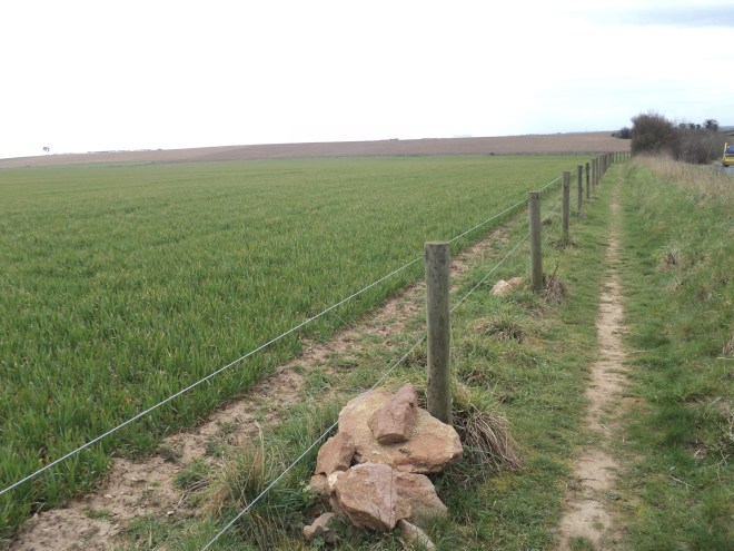
And perhaps the most significant event of all was the Battle of Towton, which took place on 29 March 1461 (or 555 years ago today if you prefer). Historical opinion seems to vary on the exact scale of the battle, but clearly tens of thousands of men were involved, of which a very high proportion died, and the Yorkist’s victory over the Lancastrians dictated national events for the next 24 years. Visiting the battlefield today, the Towton Battlefield Society has created an excellent 2-mile Battlefield Trail which manages to combine a full interpretation of events into (perhaps ironically) a pleasant country ramble, which is described below.

Allow up to 2 hours to complete the full circuit. Most of it is around fields but a map is not really needed as the Trail is clearly marked and easy to follow. The route is flattish with a few undulations, and although I went when it was bone dry some parts could get muddy, so choose footwear accordingly.

Start at the lay-by next to the memorial cross on the B1217, half a mile south of Towton village, which itself lies 3 miles south of Tadcaster. The trail is divided into 2 sections, each section covering the 2 main phases of the battle. What becomes immediately obvious is how the geography of the landscape around you helps your understanding of the turn of events. The first section is a simple “there and back” of half a mile which takes you to the first of 10 interpretation panels that line the route. At the cross, you are on the line of the Lancastrians’ position at the start of the battle early in the morning. Ahead of you is a minor vale, with the horizon 200 yards away being the Yorkists’ initial line. So, much of the day’s action (and it was a full day, which partly accounts for casualty figures) took place right where you’re walking, a sobering thought.

DSC02375Returning to the cross, the remainder of the route covers the ground of the Lancastrians’ retreat and ultimate defeat. Late in the day of the battle, Yorkist reinforcements arrived which turned the tide in their favour. This put the Lancastrians to flight, but while the initial phases were fought on relatively flat ground, the line of escape was down into the valley of the Cock Beck. Many of the retreating soldiers met their grisly end trying to cross the Beck (which was swollen by falling snow). From Panels 4 and 5 you view the so-called “Bloody Meadow”, which tells its own story. The Trail follows the edge of the escarpment, so it is easy to imagine the difficulties the retreating soldiers faced.

After a mile of easy walking along a green track, passing more interpretation panels, the route enters Towton village where refreshment is available (when open) at The Rockingham Arms – you might need a pint by then. The remainder of the route follows the road back to the starting point, although happily most of this is on a path to the side of the road, which makes the route possible not just for grown-ups but for families with kids as well.

In closing, when I got back to the car on this particular chilly March day in 2016 I reflected that all I really had to worry about was how long it would take for the heater to kick in and for my feet to warm up. The soldiers on that snowy morning in March 1461 faced a somewhat starker reality. Perhaps we can’t be reminded too often how lucky we are to live in such relatively peaceful times.

Recognise this Meanwood building?

WP_20141219_001

Source: West Yorkshire Archive Service

Here are some clues. The photo was taken in 1920 and the bowling green in the foreground, with its shed, bench and decorative flower pot, is now occupied by flats. And because of this, it’s not possible to take a photo from the same location today. Here’s the nearest possible equivalent:

DSC02313Of course, this is Meanwood Towers, one of the most eccentric-looking buildings in the area. I came across the 1920 photo last year during a visit to West Yorkshire Archive Service (who have kindly confirmed that the photo can be published) and the comparison between then and now is fascinating. The building itself has altered slightly with some of the taller chimneys and the top tower removed for safety reasons many years ago. But what is most striking is how the Towers stood alone from any other buildings in 1920 – indeed the photo is taken from a “sales particulars” document designed to attract potential buyers of the Towers and surrounding estate. Now, the Towers are hemmed in by housing and the view above is obscured in summer when the trees are in leaf.

I find this a pretty good example of why local history can be so interesting – things we take for granted today were not always the same way. It’s worthwhile from time to time browsing the terrific Leodis photographic archive of Leeds and seeing how places across the city have changed over the years. Search using the keyword Meanwood Towers to see the existing old photos of the Towers on the site – I will ask for the 1920 photo to be added.

There is one outstanding mystery about Meanwood Towers if anyone can help. When originally built by Thomas Kennedy in the 19th century, alongside the main building was a separate 800-seat concert hall, 40 yards from the front door. Kennedy had built this to house a church organ for his wife, specially-commissioned from the Schulze organ builders in Germany; sadly, shortly after the organ was installed she fell ill and was unable to play the instrument. The organ was put up for sale and eventually ended up at St Bartholomew’s Church, Armley, where it remains to this day. Now I’m not really a great appreciator of church organ music (I’m more of a Springsteen man myself) but the literature suggests that the quality of the workmanship and its setting in St Bart’s makes the Armley Schulze Organ one of the best-regarded of all such instruments.

Which is all quite remarkable given that it began life 150 years ago in a dedicated 800-seat venue on a site now occupied by suburban housing on Towers Way in Meanwood. The organ house was built of wood and with the organ gone it slowly became dilapidated, and maps of the area indicate that it was finally removed in the 1940s. I’ve never found a photograph of the organ house (unfortunately there wasn’t one in the 1920 sales particulars) so does anyone have one they are willing to share?

First day of spring?

It certainly felt like it earlier this morning on a round of one of my favourite local circuits.

Started from the mini roundabout on Tongue Lane, then around the Woodleas path to the cricket pitch on Parkside Road. The daffs are out which added to this always picturesque scene:

DSC02342Then down through the woods to the beck. This stretch of the woods is one of my favourites – wooded definitely, but very open and light. A great place to bring the kids who can run wild but never got lost:

DSC02343Across the beck by the weir. I’ve always rather liked the way the curved branch of the tree in the foreground frames the scene (an effect only visible during the winter months): DSC02349From here I chose to follow the beck to Weetwood Mill Lane, then up the lane, left down the footpath near the top and across Tetley Field to the duckpond. Having walked through woodland since the cricket pitch, I was once again struck by the contrast of a wide open space, an effect I hope illustrated by this photograph:

DSC02357Finally, through the park and home via the shops. Looking forward to a few more rounds like this in the summer months of 2016!


Why Tetley Field matters to Meanwood

My previous blogs have covered the potential threat to Tetley Field from housing development. Tetley Field is located in Weetwood ward and is usually approached from the public right of way that connects Weetwood Avenue and Weetwood Mill Lane. Weetwood residents have expressed concern about the threat to the Field on their doorstep and, through the Weetwood Residents Association, have made effective initial representations to Leeds Councillors. So, why then should the threat to the Field be of any concern to Meanwood residents?

My answer to this question would be “because the existing character of the wider Meanwood Valley is so valuable to Meanwood residents”. Exploring the Valley is one of the best things about living in Meanwood, and one of the distinctive aspects of the Valley is the way the various open spaces link up. So, if you take Meanwood Park as a kind of “base”, it is possible from there to explore on foot Meanwood Woods, Adel Woods, The Hollies, the Woodleas, the lower Meanwood Valley and Woodhouse Ridge without passing through any significant built up areas.

And Tetley Field can be added to this list. Although access to the Field from Meanwood Park is not immediately obvious and so possibly not well-known by Meanwood residents, it is in fact only 30 seconds walk from Meanwood Park duckpond, one of the most visited spots in the Valley and itself only 5 minutes walk from the car park at the end of Green Road. Round the back of the pond, through the gap in the fence and you’re on the Field – see below:

DSC02331

The path to Tetley Field from the duckpond

DSC02310

Access to Tetley Field behind the duckpond

Once on the Field, the most immediate first impression is the open-ness of the space. Much of the Valley is wooded so the wider-reaching views of the Field come as a pleasant contrast, and of course a different range of habitats are present, both of which only enhance the Field’s importance. The paths across the Field then act as useful routes to The Hollies via Weetwood Mill Lane or back towards Meanwood Park via Weetwood Avenue.

The Field immediately borders Meanwood Park and is only really separated from it by the (ugly) iron fence that currently surrounds most of the Field. Should the existing natural character of the Field be retained in the long-term, it is quite conceivable that the Field could be much more accessible from the Park, or even become part of the Park itself.

So, to sum up, Tetley Field has value to Meanwood as well as Weetwood residents, and so representations from the Meanwood community have the potential to complement well those already made by residents of Weetwood. This could be crucial in the event of a planning application to build houses on the Field.

A good day for the Meanwood Valley

Earlier today (3 March) I attended, as a viewing member of the public, the City Plans Panel meeting where Leeds Council Members discussed the proposals for Tetley Field and the wider plans concerning Headingley Stadium. I’m glad to say that Members expressed some significant concerns about the proposals.

The section of the meeting concerning the Stadium plans began with a presentation from the developer (representatives of Leeds Rugby), followed by a response from Weetwood Residents Association on behalf of the local community, concluding with questions and comments from Members. Full minutes of the meeting will follow shortly on http://democracy.leeds.gov.uk, but I feel it is reasonable at this early stage to share my general impressions of Members’ views:

Planning process

Members’ key concern regarded the planning process adopted by the developer. The plans were presented to the meeting as 3 “Pre-Applications”, one concerning the redevelopment of the Stadium itself, the other two concerning the proposed housing developments at Weetwood and Tingley. The key problem Members had was that the Stadium plans were presented as being dependent on the granting of planning permission for the two housing sites. Members were uncomfortable with this and stated that they would prefer the applications to be presented separately, so they could be considered individually on their own merits.

Timing

A related issue was timing. The developer stated that they have a tight timescale (driven by the requirements of the cricket authorities), and hope to begin building this September. Members commented that this may well be too tight a timescale, both in terms of the Site Allocation process for these two Green Belt sites, and in terms of a planning application itself which may need be referred to the Secretary of State.

Local benefits

Another problem Members commented on was the lack of direct benefits to local residents. The developer made the case that there would be local community benefit through the improved Stadium and through the rugby and cricket clubs’ community/charitable activities. Members felt however that this argument was weak and that there were no obvious direct benefits to residents in Weetwood or Tingley from the Stadium redevelopment.

Uncertainties

In addition, two underlying uncertainties were commented on. Firstly, a redeveloped Stadium would not necessarily guarantee the future of international cricket at Headingley. Secondly, uncertainties over the funding package proposed.


As these were Pre-Applications, no formal recommendations were made by Members, but my strong impression was that they had significant reservations about the plans. The developers’ presentation mentioned that they intended to make their 3 planning applications before the end of March. It will be interesting to see if this turns out to be the case in the light of Members’ comments. The next meeting of the City Plans Panel is on 24 March.

It should be mentioned in closing that Weetwood Residents Association’s presentation was both convincing and professional, and I am grateful that they were able to make such an effective representation on behalf of local residents like myself.


(4 March update – the Yorkshire Evening Post has also covered this story)

Councillors to discuss plans for Tetley Field

Leeds Council Members will be discussing the proposals for Tetley Field and the wider plans concerning Headingley Stadium at the Thursday 3 March meeting of the City Plans Panel. As far as I’m aware this is the first formal discussion by Councillors on the plans since their release back in January.

The Public Document Pack for the meeting is now available to view. It includes a report of the Chief Planning Officer, which is presented from pp 33-48.

The meeting will receive the Chief Planning Officer’s report and the applicant and their representatives will present the proposed schemes. Opportunity will be given for local community representatives to respond.

Members will be invited to provide feedback on the following questions raised in the report:

  1. Do Members have any comments on the principle of development at Headingley Stadium and at Weetwood and Tingley and particularly the bringing forward development of the two housing sites in advance of the Site Allocations process?
  2. Do Members have any comments on design considerations for either the Stands or the Housing schemes?
  3. Do Members have any comments about the impact of the Weetwood development on the character and appearance of this part of the Weetwood Conservation Area?
  4. Do Members have any comments on highway issues at either the Stadium or the Weetwood and Tingley Sites?
  5. Are there any other issues or comments that Members would like to raise or make at this stage?

The meeting takes place at Civic Hall from 1.30pm and is open to the public. A site visit preceeds the meeting at 11.40am.

A further blog on this topic will follow shortly after the meeting.