Recce
(reki )
verb
If you recce an area, you visit that place in order to become familiar with it. People usually recce an area when they are going to return at a later time to do something there.
[British, old-fashioned]
Sun 21 October
I’m at Langsett Barn, a few miles north of Sheffield, on the edge of the Peak District. I’m here to recce the route of next Sunday’s Grin n Bear It fell race, a 15 miler across the moors of the Dark Peak.
Although I’ve been in this area once or twice before, it’s not been for several years. The weather is warmish for the time of year; clear at lower level but misty on the tops. I’ve got the trusty 1:25000 OS map and a 2-sided description of the route. Also carrying waterproofs, hat, gloves, compass, whistle + a bit of food and water.
I note a few things before setting off. It’s taken just under an hour to drive here. It’s a busy Sunday and the car park is full, but there’s space on the road nearby. There are toilets.
15 miles is a fair way and I set off at a gentle jog. There’s a plethora of paths through the woods before you get to the moors, but the route will be marked through here on race day, so I just choose one at random. They all converge on Brookhouse Bridge, a mile further on, where the crossing of the moor starts in earnest.
The initial climb is long and gentle on a clear trail. Coming down the other side it’s a bit steeper, including a long hairpin bend with an obvious short cut. The trail continues up the narrowing valley of the River Derwent. I note the exact locations of the race checkpoints. It’s all been pretty straightforward up to now – half the route done, in a little under 2 hours, and I have a stop for a bite to eat and a drink.
At this point, things become more tricky. The mist descends and the rain sweeps in. I have a final look at the map – follow the stream to its head and you should pop out at Checkpoint 3 (Swains Head) – and tuck it into my pocket. Then it’s head down and onwards, as the track thins to a path, then to a trod, and finally to nothing at all, as visibility reduces to a few yards.
Approaching where I guess Swains Head should be, I come across a fence in an otherwise featureless landscape. The fence looks new and isn’t marked on my map. Compass out. The fence is heading vaguely northwards. If the worst comes to the worst, if I keep heading north I will hit the Woodhead Pass road in a mile or so. I follow the fence to a stile, where it turns a corner more directly northwards. This must be Swains Head itself, and I am back on the race route.
A couple of minutes further on, there is another stile. The route description suggests that you cross it. I do so, and end up straightaway in a deep boggy grough. Turn round, back over the stile, try the other side. Even worse, and I have a near miss when my left leg disappears down an invisible hole and I escape with a minor graze. So back to the stile again, through the grough and onto easier ground.
Further on, there is a second navigational section over open ground. Following a bearing, I successfully locate a line of grouse butts. The map tells me that the final checkpoint (a barn) is down the slope to the right. I drop down a little, out of the mist, and there is the barn, tucked mischievously into the side of the hill.
The remainder of the route is a simple 3-mile jog along clear tracks. I get back to Langsett a little under 4 hours after I set out. Given that this will be my first “Long” race for some time, I’d be happy with that next week.
Sun 28 October
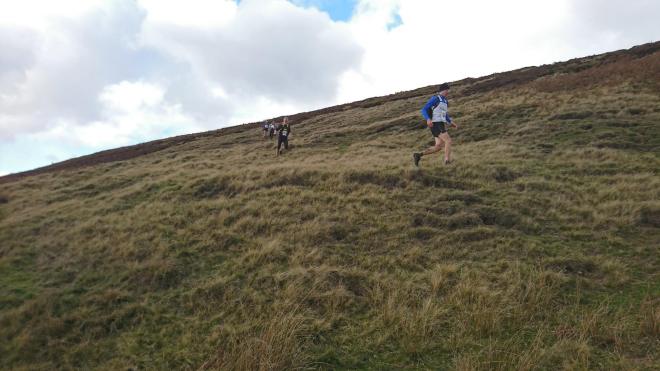
The race. It’s clear and cold, visibility is perfect. I arrive an hour early, which helps as there’s a full kit check before you get your race number. We set off and again I do the first climb at a steady jog. Over the top though the descent is such fun I start stretching out. I shortcut the hairpin. And I chat to a few other runners. Have you done the race before? No. Have you been round the route? No, I’m just following everyone else. Do you know there are some pathless bits? I thought it was mainly trails…
This time there is an obvious short-cut towards Swains Head, which today is clearly visible, being marshalled by 4 red-jacketed members of Woodhead Mountain Rescue Team. I cross the stile 2 minutes further on. A group 100 yards ahead of me have run past it. At the bottom of the hill, I’m 100 yards ahead of them.
Further on, I pass the grouse butts and head down the slope towards the invisible barn. Again, a group in front of me just follow the lie of the land and miss it. Some are making a dog leg to visit the checkpoint they only belatedly spotted. Later on, photos show runners coming the wrong way down the track as they have completely overshot.
I’ve still got plenty in the tank on the run in. When I cross the finish line, it’s in 2 hours 35 minutes, 1 and a quarter hours quicker than last week. I feel a bit smug about my recce. But that’s fellrunning.